
Cristoforo Sabbadino, Lagoon Maps number 8 and 124, 16th century
Archivi di Stato di Venezia
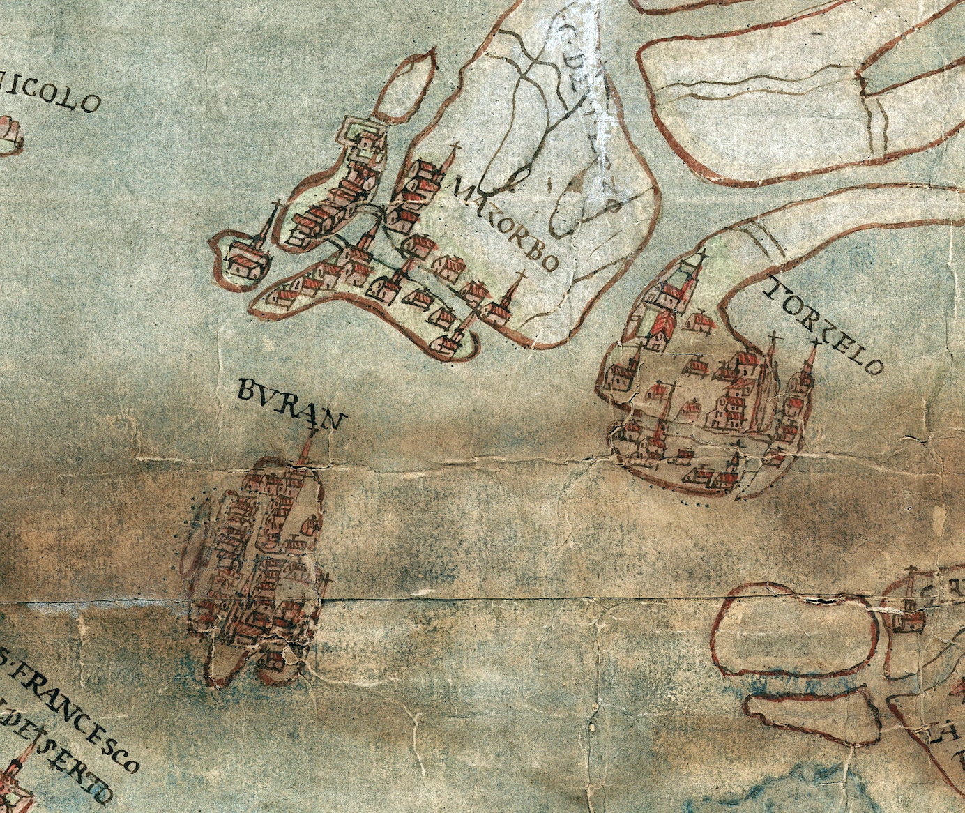
The detail above (lightened for legibility) of map 8 shows the islands of Burano, Mazzorbo and Torcello in the centre.
Project:
Conservation of two maps by Cristoforo Sabbadino
Location:
Archivi di Stato di Venezia
Conservators:
Luana Franceschet
Stefania Moretto
Start Date:
Spring 2026
Fully Funded:
€4,243
Regarded as one of the most innovative hydraulic engineers of his time, Cristoforo Sabbadino was appointed by the Signoria in 1536 as an expert of the Venetian Republic to examine proposals submitted by the Savi alle Acque (Waterways Authority) concerning the regulation of the Brenta River. In 1542, he was appointed Proto-maestro alle Acque (Chief Waterways Engineer) and shortly thereafter became the Republic’s principal consultant on hydraulic affairs. He went on to create a series of maps documenting the waters surrounding the city, including the lidi and the rivers that flowed into the lagoon.
Two of these maps; no. 8 (Venice Lagoon, 1350 × 810 mm, paper) and no. 124 (Venice Lagoon, 580 × 433 mm, paper), part of a collection of twelve now held by the Archivi di Stato di Venezia, will undergo conservation treatment. They are pencil, ink, and watercolour drawings on assembled papers of varying colours and weights. The works are mounted on canvas with a coloured edge trim and feature handwritten or printed labels on the reverse. The restorers appointed to this project are Luana Franceschet and Stefania Moretto. The Austrian committee Venedig Lebt is supporting the conservation of the wider series, some of which has already been completed.
Sabbadino’s maps record the history of a lagoon that no longer exists in the same form today. Its connections between land and water changed over time, leading to the loss of entire islands, such as L’Ammiana and Sant’Ilario, and reshaping itself as rivers flowed or new channels were dug. These maps are essential for understanding the lagoon’s evolution, the fragile balance that sustains it, and the ongoing effects of climate change.
The two maps selected for conservation by Venice in Peril document the inland fringes of the Venetian lagoon, which were subject to constant change, both because of silt deposited from the rivers and the continual process of diversion and canalisation of the waterways.
The beautiful, coloured map, Laguna 8 (01389), shows the northern section of the lagoon, extending from Mestre on the left, past the site of the present airport at Tessera, to the market-gardening area of Sant’Erasmo at the bottom. In an inscription dated 22nd May 1545, Sabbadino proudly testifies that the map is based on his own on-site survey and drawn in his own hand.
The smaller of the two drawings, Laguna 124 (012184) is drawn in brown ink and is map is notable as a working sketch by Sabbadino. It records the intricate topography of the western edge of the lagoon from Fusina towards Marghera. The canal of the Brenta Nuova runs in a straight line across the centre of the map. This artificial waterway is crossed by numerous natural rivers such as the Botteniga, which flow into the lagoon forming a rather irregular and constantly shifting delta. In this case Sabbadino states that he has made a reduced image of this part of the lagoon based on “authentic” larger scale drawings by two other draughtsmen. As the chief engineer of the Savi ed Esecutori alle Acque he had access to a team of professional surveyors.
Both maps are in large format and lined with canvas. Considered to be amongst those in urgent need of conservation, they were stored rolled up and have suffered from damp. Treatment will include the following: Written and photographic documentation of the intervention. Gentle surface cleaning using a latex sponge, soft brush, and (where needed) light vacuuming of the reverse. Testing of ink and watercolour stability. Removal and preservation of the original edge trim, along with selective removal of old repairs. Local consolidation of fragile areas, followed by removal of the backing canvas and reduction of adhesive residues.
Stains will be reduced where necessary, and tears or losses are repaired with toned Japanese paper. The works will then be lined with Japanese paper for support and flattened. A new edge trim, matched to the original, will be applied. Minimal retouching will be carried out only where essential. Original inscriptions and labels to be preserved separately when required. Finally, the works will be rehoused in custom archival boxes.
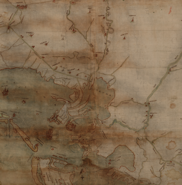
Map no. 8 (Venice Lagoon, 1350 × 810 mm, paper
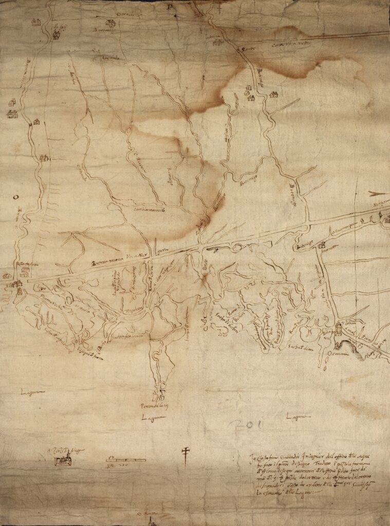
Map no. 124 (Venice Lagoon, 580 × 433 mm), paper